Meteorology - South Downs Hang Gliding
 Weather
The study and understanding of the weather is essential in all forms of aviation. Gliding involves exploiting the rising currents of air to prolong flight. In powered aircraft "weather" is often something to be avoided, but for glider pilots, it is the power under our wings. Reading and understanding the weather are equivalent to the power-pilot's fuel tanks and motor. We not only learn to avoid unsafe flying conditions, but we can find rising air currents from knowledge od meteorology.
Flying Conditions
Hang-gliding can tolerate winds of up to 30mph. Stronger winds are usually very turbulent and unpleasant to fly in. Also they are restrictive in that, in order to remain over the same spot of ground, the pilot will have to fly the glider at an airspeed equivalent to the speed of the wind. Traveling upwind takes a long time and turning downwind will carry the glider very fast......the windspeed plus the airspeed. A light breeze offers the best flying conditions, where there is enough updraft to provide ridge-lift where the pilot can wait to encounter some thermal lift. With a light wind the drift of a thermal will be slow, there will be plenty of time to gain altitude whilst staying within gliding range of the launch point; time to make the decision whether or not to continue with the thermal and fly cross-country or return to the ridge-lift.
Moving Air
A "parcel" of air, we shall define as a volume of air, many times larger than our hang-glider, in which we consider the air to be still. From the definition it follows that a glider will descend down its glide-slope through our parcel of air. If we know how this parcel moves in relation to the ground then we can infer how the glider will move as seen from the ground. For example, if the parcel of air is rising at the same rate as the glider descends, height will be maintained.
Properties of the Air
The air is a mixture of gases, nitrogen, oxygen, carbon-dioxide, water vapour, etc. Because gases are compressible the air is most dense at the surface. As we gain altitude the air gets thinner, less dense. At about 20,000ft. the air is half as dense as at sea-level, half of the total weight of the atmosphere is below this height. At the upper most reaches, above some 50,000ft., in the stratosphere, the air is very thin. Below this height is the troposphere where the air is in constant motion. The weight of the air above us at the surface is called air-pressure which we measure with a barometer. Sometimes air piles up on top of us, to a greater depth, giving a "high" pressure. At other times, less depth of air, will give us a lower pressure. If we ride up through the air with a barometer we would see the pressure dropping. An altimeter, measuring altitude, is a barometer with a scale in thousands of feet instead of millibars of mercury. This is why you have to set the zero on the altimeter on any particular day's flying. If it's reading a higher altitude than on the previous day, then you know that the atmospheric pressure has fallen......."Increasing cloud and more likelihood of rain", says the dial on a household barometer. So you can use your altimeter for a basic weather forecast.
Clouds
 If we take a quantity of air
and increase the pressure on it, the volume will decrease and the
temperature will increase. Rising air will increase in volume and cool,
falling air will decrease in volume and become warmer. Such changes are
called adiabatic. Another important property of the air is the
humidity. This is the amount of water vapour in the air. Warmer air has
greater capacity to carry water vapour than cooler air. So as air cools
a temperature is reached where it can no longer hold the water in
vapour form, this is called the dew-point. Here the air is fully
saturated and begins to form tiny droplets of water which we can see as
cloud. If condensation continues then these droplets become larger,
eventually falling as rain.
If we take a quantity of air
and increase the pressure on it, the volume will decrease and the
temperature will increase. Rising air will increase in volume and cool,
falling air will decrease in volume and become warmer. Such changes are
called adiabatic. Another important property of the air is the
humidity. This is the amount of water vapour in the air. Warmer air has
greater capacity to carry water vapour than cooler air. So as air cools
a temperature is reached where it can no longer hold the water in
vapour form, this is called the dew-point. Here the air is fully
saturated and begins to form tiny droplets of water which we can see as
cloud. If condensation continues then these droplets become larger,
eventually falling as rain.
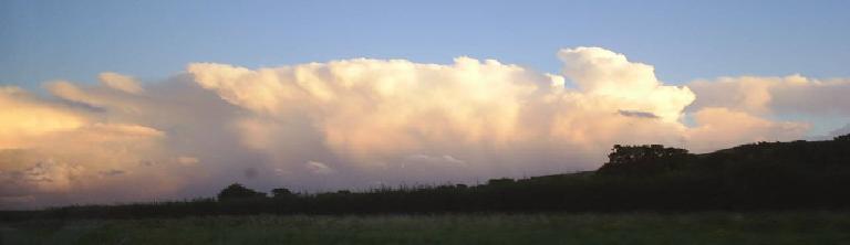
Clouds reveal the presence of rising air. The different shapes of
clouds can tell us where the air is rising fast or relatively slowly.
Clouds are described by giving them names according to their shape,
(stratus or cumulus), their altitude, (alto- or cirrus), and if they
are likely to rain, (nimbus). Learning the cloud types will help
determine flying conditions and will help with forecasting. The air is
usually invisible, only clouds on such a grand scale make the air
movements apparent. There is a lot to learn by cloud watching and
working out how they've been formed.
Fog is an example where cloud forms without rising air. Radiation fog
is where the air cools by the ground radiating it's heat away to the
sky during the night. Warm air passing over a colder sea causes sea fog.
Global Weather
 Differences
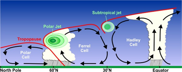
in temperature drives the World's weather system. At the Equator the
air is much warmer than at the Poles. This starts convection: warmer
air rises drawing colder air down from the poles. In turn the warmer
air high up flows out toward the poles to replace the cold air. Because
the Earth is spinning, the upper air moving away from the equator has
greater rotational energy than the lower cold air leaving the poles.
This breaks the simple convection into three parts. In the northern
hemisphere this sets up the high level westerly (from the west) "jet
stream" winds, and is the reason for the drift of the weather patterns
in our region of the world. "Coriolis effect" is the name given to the
tendency for moving objects to deviate from a straight course when on a
spinning surface. In practice anything which moves in the north
hemisphere will experience a small turn to the right, in the south
hemisphere, to the left. When we pull the plug in a bath the water
moves toward the hole. All the molecules experience the coriolis effect
and turn slightly to the right, (as seen from above), forming a
whirlpool spinning anti-clockwise. Australians see their bath water
spinning clockwise!
Differences
in temperature drives the World's weather system. At the Equator the
air is much warmer than at the Poles. This starts convection: warmer
air rises drawing colder air down from the poles. In turn the warmer
air high up flows out toward the poles to replace the cold air. Because
the Earth is spinning, the upper air moving away from the equator has
greater rotational energy than the lower cold air leaving the poles.
This breaks the simple convection into three parts. In the northern
hemisphere this sets up the high level westerly (from the west) "jet
stream" winds, and is the reason for the drift of the weather patterns
in our region of the world. "Coriolis effect" is the name given to the
tendency for moving objects to deviate from a straight course when on a
spinning surface. In practice anything which moves in the north
hemisphere will experience a small turn to the right, in the south
hemisphere, to the left. When we pull the plug in a bath the water
moves toward the hole. All the molecules experience the coriolis effect
and turn slightly to the right, (as seen from above), forming a
whirlpool spinning anti-clockwise. Australians see their bath water
spinning clockwise!
The jet-stream wiggles around the earth lowering the surface air
pressure beneath it's track. In these wiggles of the upper air are born
the high and low pressure systems. Once born these pressure differences
will try to equalise so the air will move from the higher pressure
region toward the lower pressure region. In doing so, it deviates due
to the coriolis effect, and so the surface winds spiral clockwise out
from a high pressure region and spiral anti-clockwise in to fill lower
pressure areas.
Synoptic Charts
In order to study the weather meteorologists measure the
properties of the air from sea and ground-based weather stations and
from airbourne sources such as aircraft and balloons. They also have
information from satellites orbiting the earth.  The information is displayed
in a synoptic chart. This is the weather map familiar from TV weather
forecasts and printed in the daily newspapers. Areas of equal pressure
are connected by lines called isobars. On the chart they form rings
similar to the contour lines on a conventional map. In fact they are
like contour lines drawn to show the bumps and hollows at the edge of
the atmosphere! For this reason the low is often called a depression.
The air will flow down the pressure gradient, that is, from the centre
of the high toward the centre of the low. The steeper this gradient,
(shown by isobars close together), the greater the force. Remember the
coriolis force will deviate this flow to along the isobars instead of
across, clockwise out of a high, anti-clockwise in toward the low.
However, the air near to the ground is slowed by surface friction,
therefore deviates less. So near the ground the wind will tend to blow
at an angle to the isobars. This leads to the curious fact that the
wind will always turn clockwise with an increase in altitude. If there
is a 10mph westerly at ground level it's likley to be a 15mph
north-westerly higher up. The weather is a complex chaotic system
determined by the movements of the air in interaction with the ground
and seas. Temperature varies greatly over the land by day and night,
less so over the sea. Air flowing over the ocean will absorb more
water, over the land, less, but will be subjected to larger temperature
changes; and, contour changes (hills and mountains), and texture
differences (cities, rocks or vegetation).
The information is displayed
in a synoptic chart. This is the weather map familiar from TV weather
forecasts and printed in the daily newspapers. Areas of equal pressure
are connected by lines called isobars. On the chart they form rings
similar to the contour lines on a conventional map. In fact they are
like contour lines drawn to show the bumps and hollows at the edge of
the atmosphere! For this reason the low is often called a depression.
The air will flow down the pressure gradient, that is, from the centre
of the high toward the centre of the low. The steeper this gradient,
(shown by isobars close together), the greater the force. Remember the
coriolis force will deviate this flow to along the isobars instead of
across, clockwise out of a high, anti-clockwise in toward the low.
However, the air near to the ground is slowed by surface friction,
therefore deviates less. So near the ground the wind will tend to blow
at an angle to the isobars. This leads to the curious fact that the
wind will always turn clockwise with an increase in altitude. If there
is a 10mph westerly at ground level it's likley to be a 15mph
north-westerly higher up. The weather is a complex chaotic system
determined by the movements of the air in interaction with the ground
and seas. Temperature varies greatly over the land by day and night,
less so over the sea. Air flowing over the ocean will absorb more
water, over the land, less, but will be subjected to larger temperature
changes; and, contour changes (hills and mountains), and texture
differences (cities, rocks or vegetation).
Atmospheric Stability
 A "sounding" involves sampling the air in a
vertical
direction. Met offices around the world take actual soundings using
weather balloons. Results are typcally shown in a graph with a skewed
temperature scale against height ("skew-t"). It is highly recommended
that glider pilots become familiar with reading these charts.
The example shown here
forecasts a 5000ft cloudbase and 25,000ft cloudtops when the ground
temperature reaches 26 deg. When clouds begin to form on this day they
will rapidly develop into cumulo-nimbus.
A "sounding" involves sampling the air in a
vertical
direction. Met offices around the world take actual soundings using
weather balloons. Results are typcally shown in a graph with a skewed
temperature scale against height ("skew-t"). It is highly recommended
that glider pilots become familiar with reading these charts.
The example shown here
forecasts a 5000ft cloudbase and 25,000ft cloudtops when the ground
temperature reaches 26 deg. When clouds begin to form on this day they
will rapidly develop into cumulo-nimbus.
Turbulence involves the air flowing any which way. Flying the hang-glider will result in a bumpy ride with consequent difficulty in predicting the flight path of the glide. Stable air will resist vertical motion so turbulent flow is restricted to two dimensions instead of three. The stability of the air can be defined as the tendency of the air to convect, or the tendency for vertical motion. Many people are unaware that the air changes in this way. On a stable day the air will prefer to flow around a hill rather than up and over it and changes of surface temperature will not result in rising warm air currents. The options for soaring flight will be limited: a ridge facing the wind, or a bowl, will force the air to rise over it , there is no alternative route, however, little height will be gained by the soaring hang-glider. In unstable air the flow becomes more chaotic. Rising air will continue to rise and be replaced by falling air, an object in the path of the wind will give rise to turbulence which may continue long past the object, (tree, building, etc.,), and may even increase! The air can be stable at one level and unstable at another; and, during the day, the degree of atmospheric instability will change. This condition of the air depends upon the change of temperature with height. If there is little or no change the air will be stable, when the air cools rapidly with gaining height the air will be unstable.
Weather Fronts
When considering large bodies of air which differ in their essential characteristics, temperature, humidity, etc., we call such blocks of air, air masses. To fill a low pressure area, colder, denser, polar air moves down from the north, and warmer tropical air moves up from the south. The meeting of these different temperature air-masses are called weather fronts. A "cold front" when cold air advances on warmer air, and a "warm front" when warm air advances on colder air. Both types of front are likely to produce rain, but the clouds and airflow pattern are very different. The cold and warm fronts are shown on the synoptic chart as a line with triangles or semicircles, respectively. The fronts will circle around the low in an anti-clockwise direction.due to the coriolis effect. Cold, dense air from the north is called a polar air mass, and warm, wet air from the south, a tropical air mass. Polar and tropical air-masses are further distinguished as continental or maritime if they originate over the land or sea. For instance, a tropical maritime air-mass will be warm and wet, whereas, a polar continental air-mass will be cold and dry. When these air masses meet, warmer air is forced to rise forming distinct types of cloud and rain. In a cold front where the polar mass advances, the warmer air is scooped up by the dense wedge of cold air forming large cumulo-nimbus clouds. Plenty of lift but dangerous flying conditions! The comparitively docile warm front spills over the top of colder air at a gradual incline, forming flat stratus cloud extending over a wide region. On the synoptic chart the fronts are usually drawn along the line where the front gives rise to rain. Cold fronts move at the speed of the surface wind and so tend to catch up the warm front leading to the situation where one is on top of the other, this is called an occlusion or occluded front. These have the characteristics of both warm and cold fronts.
Thermals
 Thermal
lift will occur where a local temperature increase of the ground warms
the air immediately above, lowering its density, forcing it to rise.
Usually this happens by the sun differentially heating darker, less
reflective, areas on the ground. A ploughed field surrounded by
meadows, or a village in the countryside, for example. The "thermal"
will continue to rise until it cools to the temperature of the
surrounding air. As it rises the air pressure decreases so it expands
and therefore cools adiabatically at approximately 3 deg.C per 1000ft.
Cooling by mixing and radiation is small compared to this adiabatic
cooling. If the surrounding air also cools at near this rate then the
thermal will maintain its buoyancy, remain warmer, as it climbs. The
thermal will continue to rise until it is the same temperature as the
surrounding air. With sufficient moisture in the air a cumulus cloud
will form marking the position of the thermal for glider pilots. In dry
air the cloud-base will be higher, or in very dry air "blue thermals"
will not give rise to cumulus clouds.
Thermal
lift will occur where a local temperature increase of the ground warms
the air immediately above, lowering its density, forcing it to rise.
Usually this happens by the sun differentially heating darker, less
reflective, areas on the ground. A ploughed field surrounded by
meadows, or a village in the countryside, for example. The "thermal"
will continue to rise until it cools to the temperature of the
surrounding air. As it rises the air pressure decreases so it expands
and therefore cools adiabatically at approximately 3 deg.C per 1000ft.
Cooling by mixing and radiation is small compared to this adiabatic
cooling. If the surrounding air also cools at near this rate then the
thermal will maintain its buoyancy, remain warmer, as it climbs. The
thermal will continue to rise until it is the same temperature as the
surrounding air. With sufficient moisture in the air a cumulus cloud
will form marking the position of the thermal for glider pilots. In dry
air the cloud-base will be higher, or in very dry air "blue thermals"
will not give rise to cumulus clouds.
Wind Shear and Turbulence
Where streams of air flow in different directions to each other in close proximity the wind is said to shear. For example where the two layers of a warm front meet or at the edges of a rising thermal bubble. A change in the speed and direction of the airflow will affect the glider's airspeed and control, and be felt as turbulence by the glider pilot. Increasing the airspeed will ensure the glider remains above the stall speed, and more active weight-shift in roll will be required to maintain the desired direction. It is wise to increase your margin of error by allowing more distance away from other fliers and from the side of the hill or other obstacles, also to choose a larger landing zone where the varying airflow will mean a variable glide approach and an unpredictable touchdown. If the wind is "gusting" from 5 to 15 mph a hang-glider on a glide could experience a loss or a gain of 10mph in airspeed. Most hang-gliders have a stalling speed of about 15mph, so to avoid a gust induced stall an airspeed of at least 25mph must be maintained. Modern hang-gliders will quickly recover from a stall without pilot input but will lose height (up to 60ft) before recovering airspeed and directional control. Stronger wind will in general produce more turbulence by interaction with obstacles on the ground. Thermals represent a vertical shear in the air. So not all turbulence is a bad thing! Choppy air on a summer day tells the pilot there is a thermal nearby. A hang-glider will naturally turn away from lift as one wing meets rising air before the other, so in resisting this by weight-shifting to the higher side, a turn can be made in towards the lift and height gain achieved.
Micro-meteorology
The slow flying nature of hang-gliders means that small scale air-currents and localised turbulence are of importance to the pilot, particularly when searching for lift close to the ground or when selecting a suitable landing approach. This scale of weather study is called "micro-meteorology". How the wind is disturbed by contact with the ground, around obstacles and contours. The wind-gradient is the name given to the slowing of the wind by friction with the ground. It depends on the strength of the wind and on the nature of the surface. This slowing of the wind is most severe within 50ft of the ground. Landings are normally made into the wind direction to keep the groundspeed low, as the glider descends through this gradient the wind shear progressively takes away airspeed. Given that it is critical to maintain airspeed on a landing approach the pilot should always take extra speed to descend through this last 50ft. It is good practice to do this on every landing approach just in case a severe wind-gradient exists. Generally a rough surface, trees and other obstacles, all contribute to a stronger wind gradient. This drag of the air by the ground also occurs when the wind blows up a slope. This will tend to turn a ridge-soaring hang-glider in towards the slope because of a stronger airflow on the outside wing. Also thermals are skewed by the wind-gradient, they tend to roll up the slope giving stronger lift out from the hill.
When thinking about the wind it is useful to imagine the air flowing much like water over a river-bed, following the contours of the land with turbulent eddies over and behind obstacles. The air will not flow cleanly round a sharp edge such as a cliff, in the lee will be rotoring air highly dangerous to enter with a hang-glider. Any cliff flying site needs to have a rounded edge for a safe take-off and the chance of top-landing. Any flying site will always need a bottom landing site, just in case! Ask the local pilots if you're flying unfamiliar sites.
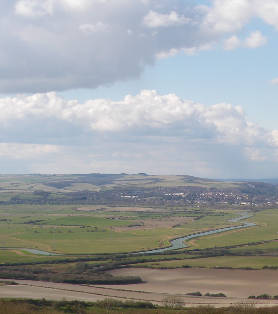
Another source of rising air useful to the glider pilot is where the wind is deflected over hills and ridges. The area of rising air where the glider maintains or gains height is called the lift-band. The vertical component of the air is greatest where the hill is steepest and the wind blows perpendicular to it. Wind strength and air stability also affect the amount of lift. Very stable air by definition is reluctant to rise, and where it's forced to rise over a hill it will compress and produce a strong venturi effect with little lift. Unstable air will easily rise over the obstacle where even light winds will produce good lift.
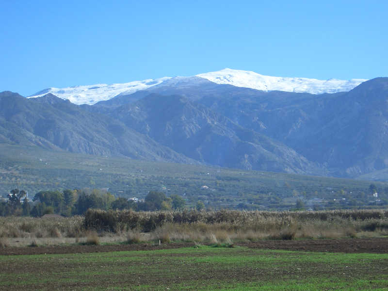
Mountains
Large mountains present an obstacle to the flow of the pressure systems and so tend to generate their own local weather. As a general rule the best conditions for mountain flying are when there is no overall wind. The airflow is then fairly predictable dominated by convection.
 If
there is a significant wind blowing through the peaks there will be
large wind shearing and therefore turbulence. A moderate wind which
would be pleasant to fly in low hills can be very dangerous in large
mountains. Light winds are essential for safe mountain flying. If the
weather forecast predicts more than a light wind in mountainous regions
then the mix of the wind, the convection and the dramatic contours will
lead to dangerous gusts and turbulence. Only certain sites will be
flyable and even then certain routes normally flown without wind could
become hazardous. A good assessment and sensible flight plan are
essential. Use local knowledge, and if you're unsure don't fly.
If
there is a significant wind blowing through the peaks there will be
large wind shearing and therefore turbulence. A moderate wind which
would be pleasant to fly in low hills can be very dangerous in large
mountains. Light winds are essential for safe mountain flying. If the
weather forecast predicts more than a light wind in mountainous regions
then the mix of the wind, the convection and the dramatic contours will
lead to dangerous gusts and turbulence. Only certain sites will be
flyable and even then certain routes normally flown without wind could
become hazardous. A good assessment and sensible flight plan are
essential. Use local knowledge, and if you're unsure don't fly.
In favourable flying conditions convection begins about mid-morning by the sun heating up the slopes facing toward the east. The thermal bubbles rise up the slopes and separate from the ground at the top and from spurs or other thermal triggers such as a line of trees or a snow-line. At noon the high sun can be heating both sides of the mountain. Thermals are generated from the peaks and spurs because there the heated ground at a higher elevation is surrounded by cooler air which is heated more than air lower down and so becomes buoyant sooner. The thermals leaving the mountain tops draws a wind up the slopes, this is called anabatic airflow. This in turn draws the air up the valleys toward higher ground. The hang-glider pilot will find lift above the sunny slopes, above the spurs and the peaks and can achieve spectacular cross-country flights amid stunning scenery. As these anabatic mountain winds pick up steep gullies and gorges should be avoided as sources of turbulence. Toward the evening the mountain slopes cool by radiation, cooling the air above which then begins to flow down, draining out of the valleys. This is called katabatic airflow. As it changes from anabatic to katabatic the air over the valley is caused to rise. This is known as valley lift or "magic lift" where a hang-glider can find large areas of smooth gentle lift lasting well into a summer evening.
Wave lift occurs where a wind blows across a series of hills or mountains setting up large scale undulations in the airflow. It is possible to gain high altitudes by soaring the upward bounce of the wave. The crest of the waves are often marked by stationary lenticular (lens-shaped) clouds with the cloud forming on the windward side and dissolving in the leeward downdraft. As with any wind blowing over large hills, wave lift can be associated with severe turbulence.
South Downs Hang Gliding
Gibraltar
Farm, Firle, East Sussex. BN8 6NB
Tel. 07890 362648
E-mail: info@southdownshanggliding.co.uk